



Lloyd Mutungwazi
ZIMBABWE must implement Geographic Information System (GIS) as well as the use of UAV (unmonitored aerial vehicle) drones in forest and wildlife conservation.
Human-caused disruptions, such as habitat loss, pollution, invasive species introduction, and climate change are a threat to wildlife health and biodiversity.
GIS technology is an effective tool for managing, analysing, and visualizing wildlife data to target areas where interventional management practices are needed to monitor their effectiveness.
Understanding the specific needs of wildlife populations is key to preventing local or global extinctions, rehabilitating populations, and restoring habitat.
Implementation of GIS and use of drones can be useful in parks and wildlife management as well as forestry commission.
GIS is a technological tool used to comprehend geography and make intelligent decisions.
GIS organizes geographic data so that a person reading a map can select data necessary for a specific project or task. This can be useful to the wildlife managers and game rangers to easily identify the areas which are mainly affected by poaching activities.
For example, a forester from Ngamo forest area might use the basemap and collect data from the field to add data layers to a map that shows areas that have been affected by veld fires for the past dry seasons.
GIS maps are interactive. On the computer screen, map users (Game rangers) can scan a GIS map in any direction, zoom in or out, and change the nature of the information contained in the map.
They can choose whether to see the roads, how many roads to see, and how roads should be depicted.
Then they can select what other items they wish to view alongside these roads such as amount, type of species, both animal and plant.
Some GIS programs are designed to perform sophisticated tasks like diseases outbreak areas and shows the distribution of invasive species in Hwange national park for instance.
Most of the countries in Africa like Ethiopia have already engaged in this technology, using GIS to save endangered species (Ethiopian wolves) which have been affected by rabies.
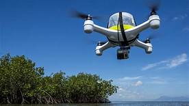
As use of unmonitored aerial vehicles was successful in Israel, introduction of it might be useful in Hwange national park. Drones will be monitor all the activities within the park without game rangers need to move long distance around the park disturbing wildlife peace as well as them vulnerable to attacks.
This technology can also minimizes cases of human and wildlife conflict as well as poaching.
Lastly from routinely performing work-related tasks to scientifically exploring the complexities of an area, GIS gives people the geographic advantage to become more productive, more aware, and more responsive citizens of planet Earth.


